The Azores, Portugal Roughly 900 miles off the coast of Lisbon, this Portuguese archipelago can inspire wanderlust with a single photo. Filled with verdant valleys, steep ocean-side cliffs, rows of blue hydrangeas, and scattering of waterfalls make the Azores a paradise worth exploring. Credit: Getty
It is our last day for touring around Maine before my wife and I return to Los Angeles through Logan Airport in Boston. And we still had so much to see. So up early and breakfast in Bar Harbor and on the road.
First stop was Schoodic Point about 4 miles away from Acadia as the crow flies but about an hour away by car. Schoodic Point is on a peninsula about 4 miles from Mt. Desert but there is no direct route there so you have to drive off the island and take Maine 1 north to the turn off for Winter Harbor. You travel down this lovely peninsula to the Schoodic Point Park. It is actually part of Acadia National Park, but much less crowded or visited. The views are amazing and the air actually smells clean – that is hard to describe, but it was the freshest air I have ever smelled. Just smelled pure.
This is a great place to picnic weather permitting and just look at the wave crashing on this rocky granite coast full of tidal pools and amazing rock formations.
Second stop was further up Maine 1 at Columbus Falls, Wild Blueberry Land. It is an iconic place to stop according to all the websites – Google, TripAdvisor, and others. Maybe back in the day – but when we dropped by other than some fun photos, the place is pretty run down and inside you can watch a baker actually make off the blueberry goodies right in front of you, there was no stock in the cases and the coffee was out. There is a putt-putt course outside – old and overgrown but still works. Maybe later in the season there is more going on!
Third stop and really the entire reason for the trip up Maine 1 was to get to West Quoddy Head Lighthouse. The most photographed lighthouse on the Eastern seaboard and one of the most iconic images of Maine. It is located in Lubec, ME, and is the eastern most point of the US before entering Canada.
You get there and it is lonely there. Nothing out this way except the lighthouse. There is a mile long nature walk in the woods surrounding the lighthouse. Deep, old woods that offer glimpses of rocky cliffs and bluffs high above the crashing waves below.
Back in the car and now looking for places to stay – not much out in this part of Maine in terms of housing. Some quaint B&B’s but also some of them looked a little sketchy. So we decided to head for Bangor in the late summer light and found a good hotel. We had dinner that night at a wonderful place called McLaughlin’s at the Marina. A two story place with great views of the Penobscot River and boats coming in after a day on the water. Food and service A+.
Final stop in Maine – Stephen King’s house. Lovely Victorian home in Bangor perfect for the Master of Horror with its spiderweb front gate. The house is really easy to find – it has its own Google map location. Do not go in please. It is a private home, but there are literally thousands of photos online from drive-byes.
Than down to Boston and home. A really wonderful adventure covering all the things I love – theatre, travel, and adventure.
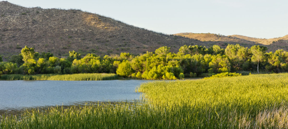
Day two on Mt. Desert Island was focused on the western side of the island. So it is less about the Acadia National Park, which while still there – this part of the island is more about local villages, fishing, and a much slower life style. Here are some images from hiking Wonderland Trail, Bass Harbor Lighthouse, Mill Cove outside Pretty Marsh Village on a wonderful bright blue day. Enjoy!!
These are views from our first day at Acadia National Park taken while driving the Park Loop Road, including Cadillac Mountain views, Jordan Pond and views from the trail around Jordan Pond, and walking the trail to Thunder Hole.
We woke up to a beautiful bright day, and after breakfast, set out for the park.
View from Cadillac Mountain
The first part of the park that you encounter as you enter is the Park Loop Drive which is on the east half of Mt. Desert Island. This takes you pass almost all the high traffic sections of the park like Cadillac Mountain, Jordan Pond and its hiking trails, the Bubbles, Thunder Hole, and the little town of Northeast Harbor.
Islands viewed from Cadillac Mountain
The first stop was Cadillac Mountain, the highest point on the North Atlantic coast and the first place in the US where you can view sunrise from October to March. At 1500+ feet, it is not really that high but it offers spectacular views of the surrounding bay and islands. Also the drop in temperature even in summer was dramatic. At the base of the mountain is was 87F’ that morning on the top with winds it was about 49F’. So bring a coat or jacket, you will need it.
Continuing along the Park Loop, you come to Jordan Pond and the historical Jordan Tea House. Finding parking in the car lot is tight so bring your peaceful, calm side because it can be frustrating and this was just the early summer season for tourists. The Park Service does offer a free shuttle service to various parts of the park, so check their website for more info and schedule on this service.
Jordan Pond
The Jordan Pond House traces its history from 1847. A man by the name of William Bennett built the first road to the pond in 1836. He had bought the land to start a logging business. He built a house and two mills. Three years later the Jordan brothers bought the property and operated the mills for many years, cutting and sawing the heavy growth of timber which covered the valleys and sides of the mountains, – and the pond gained its name.
In 1847 they built the original farm-house which forms a part of the present Jordan Pond House. The pond was named for the Jordan family for whom the pond and house were named. The Jordan Pond House was founded as a restaurant by Mr. Melvan Tibbetts in the early 1870’s. People would ride out in their carriages on the weekends from Bar Harbor to the pond and the Tea House would serve refreshments to people on the grounds while they hiked or admired the views. Both the Pond and the Bubbles are visible from the Tea House, which still serves food today.
The Bubbles
The Bubbles are two small mountains located on the northern end of Jordan Pond. They are asymmetrical pink granite hills that were abraded and smoothed on the northern side and quarried—rough and steep—on the southern side by overriding ice. The Bubbles got their name because of their unusual shape. When viewed from the southern end of Bubble Rock Jordan Pond, the twin mountains look bubble-like. They are different from most other mountains on Mount Desert Island. Rather than the typical elongated shape of most mountains there, they are instead more round.
Bubble Rock or the Balance Boulder is perched precariously on the southeast corner of the summit of the South Bubble. This large rock was transported from the area around Dedham, Maine and left in its current position as the glaciers receded thousands of years ago. Bubble Rock is clearly different from the rocks on which it sits. Bubble Rock is made of white granite rather than the pink granite that makes up the Bubbles and the surrounding mountains. It is called a glacial erratic.
From the Jordan Pond Trail
The Bubbles are accessible from two trails; there is the much steeper Southern Trail that leads from the Jordan Pond Loop Trail to the summit of the South Bubble. It is a short hike, .6 miles, and offers wonderful views of Jordan Pond and the surrounding mountains. The Bubble Trail is short, about four tenths of a mile, and not very steep, quite accessible. Start in the parking area right off of the Park Loop Road. The trail doesn’t offer any views until the summit of either mountain. Both the North and South Bubble peaks are accessible from the trail. There are no restroom facilities at the trail head.
Shoreline Jordan Pond
A carriage road on the western side of Jordan Pond provides spectacular views of the mountains. Also there is also a hiking path surrounding the pond. Jordan Pond Full Loop Trail is a 3.4 mile lightly trafficked loop trail and is rated as moderate. The trail offers a number of activity options and is best used from April until October. Dogs are also able to use this trail but must be kept on leash. Half of the hike along the pond shore is very manageable with easy pathways, but then the path than gets very difficult for older or unsteady hikers and children. Lots of climbing, elevated and narrow plank walkways, and difficult terrain so check which side of the lake suits your hiking style.
From Jordan Pond Trail 2
Our next stop was the little village of Northeast Harbor, which is located on the southern tip of Mt. Desert Island. The village was extremely quaint filled with art galleries and eateries. The village has a significant summer population, and has long been a quiet enclave of the rich and famous.We stopped at 123 Main Street Restaurant for ice cream and coffee, and a walk down to the marina. Really lovely and off the main track so there were not many tourists that day.
An interesting side note is that this part of world was settled by Quakers among other religious groups seeking a peaceful life in the New World, and there is a Quaker Friendship House in Northeast Harbor. Quakers do not believe that meeting for worship should occur in any special place. They believe that “where two or three meet together in my name, I am there among them” (Revised English Bible, Matthew, Ch 18, v 20). Therefore, meeting for worship may take place in any place.
Thunder Hole
Final stop for the day was on the east part of the Park Loop Drive. We parked and hiked about a mile by a sea-side trail to Thunder Hole. This is a natural rock inlet where waves crash with a thunderous boom & high-flying foam when seas are up. Thunder Hole is just past Sand Beach while traveling south on the Park Loop Road.
From Trail to Thunder Hole
Went back to the hotel and changed for dinner at a local eatery just outside of Bar Harbor called the Chart Room featuring classic New England seafood, pasta & prime rib are on the menu at this casual indoor/outdoor eatery. The wine was very good and dinner hit the spot. During the summer they recommend reservations – 565 Eden St, Bar Harbor, ME 04609, chartroombarharbor.com, (207) 288-9740.
Next – Acadia, Day 2
From Trail to Thunder Hole 2
Historical info by Wikipedia, photos by James Carey
Bar Harbor, while not as famous for grand “cottages” of the Gilded Age, as its neighbor to the south, Newport, Rhode Island, it did have some spectacular homes before a massive fire in 1947 burned many of them down, or they were torn down. These are some of the amazing houses still left in Bar Harbor, both private and converted for some other use. Enjoy!
PortFringe was over and we were on to the next part of our Maine excursion. We pulled out of Portland in our rental car after saying goodbye to our wonderful hosts, Laurie and Ross, and headed for Mt. Desert Island. Mt. Desert might be better known to you as Bar Harbor and Acadia National Park which are located on the very large island off the coast of Maine.
We were early in the season for Maine tourism, so the traffic on the 1 as you drove north up the coast was not to bad so we made decent time. We stopped for lunch in Camden and walked around. Pretty little town, but very touristy and crowded.
We turned off the 1 to the 3 at Ellsworth and in about 16 to 18 miles took the bridge over to the island and headed to our hotel – the High Seas Motel on Highway 3 on the outskirts of Bar Harbor. A very reasonably priced, clean family run motel with a heated pool in summer. There is morning coffee and an open kitchen area with microwave open from 7 AM to 10 PM. There is also a coin laundry on the premises for the guests.
After settling in and getting unpacked, we headed for Bar Harbor about 3PM. Bar Harbor is located along Maine’s Frenchman Bay. It serves as the gateway to the mountains and cliffs of neighboring Acadia National Park. Towering over the park, Cadillac Mountain has trails and views of the town, the bay and the Cranberry Islands. From the town pier, the Shore Path winds along the bay overlooking the Atlantic Ocean, the Porcupine Islands, and several of the remaining grand houses of the Glided Age building craze in the 1890’s.
Here I will take a moment to comment on the National Park and its relationship to the island. Acadia National Park covers much of Mt. Desert but there are many selections of the island that are purely residential. When you arrive on the island you are encouraged to buy a $40 pass that allows to travel and park in the National Park. But to be honest, we were on the island and in the National Park everyday – we were never stopped or given a ticket. I am not advocating not supporting the National Park Service, but it is not absolutely necessary to buy a Park Pass in all cases. You may run the risk of getting a parking ticket from the Park Service. Yet, with so many out of state people living on the island during the summer, it is almost impossible to keep track of all the cars and knowing who is a part-time resident or a park visitor. That said I would encourage to support the work of the National Park Service and buy a pass.
Brief History of Bar Harbor
The town of Bar Harbor was founded on the northeast shore of Mount Desert Island, which the Wabanaki Indians knew as Pemetic, meaning “range of mountains” or “mountains seen at a distance.” The Wabanaki seasonally fished, hunted and gathered berries, clams, and other shellfish in the area. They spoke of Bar Harbor as Man-es-ayd’ik (“clam-gathering place”) or Ah-bays’auk (“clambake place”), leaving great piles of shells as evidence of this abundance. In early September 1604, French explorer Samuel de Champlain ran aground on a rock ledge believed to be just off Otter Cliffs, and when he came ashore to repair his boat he met local natives. Champlain named the island Isles des Monts Deserts, meaning “island of barren mountains”—now called Mount Desert Island, the largest in Maine. The community was first settled by Europeans in 1763 by Israel Higgins and John Thomas and incorporated on February 23, 1796 as Eden, after Sir Richard Eden, an English statesman.
The Famous Balance Rock!
In the 1840s, its rugged maritime scenery attracted the Hudson River School and Luminism artists Thomas Cole, Frederic Edwin Church, William Hart and Fitz Henry Lane. Inspired by their paintings, journalists, sportsmen and “rusticators” followed. Agamont House, the first hotel in Eden, was established in 1855 by Tobias Roberts. Birch Point, the first summer estate, was built in 1868 by Alpheus Hardy.
By 1880, there were 30 hotels, and tourists were arriving by train and ferry to the Gilded Age resort that would rival Newport, Rhode Island. The rich and famous tried to outdo each other with entertaining and estates, often hiring landscape gardener and landscape architect Beatrix Farrand, a resident at local Reef Point Estate, to design their gardens. A glimpse of their lifestyles was available from the Shore Path, a walkway skirting waterfront lawns. Yachting, garden parties at the Pot & Kettle Club, and carriage rides up Cadillac Mountain were popular diversions. Others enjoyed horse-racing at Robin Hood Park-Morrell Park. Many of these grand estates and homes were burned down in a massive fire at raged in the town in 1947.
On March 3, 1918, Eden was renamed Bar Harbor, after the sand and gravel bar, visible at low tide, which leads across to Bar Island and forms the rear of the harbor. The name would become synonymous with elite wealth. It was the birthplace of vice-president Nelson Rockefeller on July 8, 1908.
Many influential people have called Bar Harbor home for at least part of the year. John D. Rockefeller, Jr., son of John D. Rockefeller of Standard Oil Co., donated about one-third of the land in Acadia National Park and built the carriage roads that are used for hiking and biking. J. P. Morgan owned a house that is adjacent to Bar Harbor. Cornelius Vanderbilt built cottages in Bar Harbor. The Astor family owned hotels and cottages in Bar Harbor and the surrounding areas. The co-founder and CEO of Burt’s Bees, Roxanne Quimby, has a home near Bar Harbor. Martha Stewart has also been known to frequent Mount Desert Island and been seen in Bar Harbor.
Shore Path
We sent the late afternoon and early evening exploring the small streets of Bar Harbor and walking along the Shore Path (described above). Seeing what remains of the houses that at one time rivaled Newport Beach in Rhode Island, as a playground of the super-wealthy. The walk starts at Argamont Park and moves along the shore till it reached Wayman Lane.
There are several yacht tours of the harbor and islands, some even on large sailing yachts, all docking and leaving from the terminal next to Argamont Park. Many of the large old homes have been converted into hotels, B&B’s and restaurants, and all with wonderful views of the harbor. And of course there are tourists, t-shirt shops and sports bars everywhere.
We opted for dinner at a natural food store on Main Street, but there are eateries of every variety to choose from all serving lobster (especially lobster rolls), haddock and salmon.
After the walk and dinner, we returned to our hotel for a bottle of wine and some time in the heated pool before the mosquitoes got too bad. Next day was Monday and that was to be part 1 of two days in Acadia.
Historical data from WikiPedia, Photos by James Carey


You must be logged in to post a comment.